AARP Hearing Center


My Settings
Guidelines
Help
Forums
- AARP Online Community
- Games
- Games Talk
- Games Tips
- Leave a Game Tip
- Ask for a Game Tip
- AARP Rewards
- AARP Rewards Connect
- Earn Activities
- Redemption
- AARP Rewards Tips
- Ask for a Rewards Tip
- Leave a Rewards Tip
- Help
- Membership
- Benefits & Discounts
- General Help
- Caregiving
- Caregiving
- Grief & Loss
- Caregiving Tips
- Ask for a Caregiving Tip
- Leave a Caregiving Tip
- Entertainment Forums
- Rock N' Roll
- Leisure & Lifestyle
- Health Forums
- Brain Health
- Healthy Living
- Medicare & Insurance
- Health Tips
- Ask for a Health Tip
- Leave a Health Tip
- Home & Family Forums
- Friends & Family
- Introduce Yourself
- Our Front Porch
- Money Forums
- Budget & Savings
- Scams & Fraud
- Retirement Forum
- Retirement
- Social Security
- Technology Forums
- Computer Questions & Tips
- Travel Forums
- Destinations
- Work & Jobs
- Work & Jobs
- AARP Online Community
- Home & Family Forums
- Our Front Porch
- Re: Weather warnings in the Upper Midwest
Weather warnings in the Upper Midwest
Reply
Topic Options
- Subscribe to RSS Feed
- Mark Topic as New
- Mark Topic as Read
- Float this Topic for Current User
- Bookmark
- Subscribe
- Printer Friendly Page
DaveMcK
Honored Social Butterfly
- Mark as New
- Bookmark
- Subscribe
- Mute
- Subscribe to RSS Feed
- Permalink
- Report
01-29-2019
10:10 AM
Weather warnings in the Upper Midwest

If you're 25 or younger and live within a large swath of the Midwest — from Minneapolis to Chicago — this week will feature the coldest temperatures of your life as a lobe of the polar vortex plunges south out of the Arctic.
Why it matters: The frigid outbreak, which has already begun in parts of Minnesota and Wisconsin, will be life-threatening and disruptive for tens of millions of people this week. Wind chills on Wednesday morning in parts of Illinois, Wisconsin and Minnesota are likely to approach the minus 50s°F to minus 60s°F. Such conditions can cause frostbite in just minutes and will likely force the cancellation of schools across the region.
Show less
Details: Weather forecasters across the Midwest have begun using words and phrases like "historic" and "all-time coldest" in association with the Arctic outbreak heading for the region. From Tuesday to Thursday, temperatures about 5,000 feet above the surface, which forecasters look to as an indicator of potential surface temperatures, may reach the coldest values ever observed in the lower 48 states.
- In Minneapolis, Milwaukee, Madison, Des Moines, Green Bay, Chicago, Indianapolis, Detroit and Chicago, the cold will peak between Tuesday and Thursday, but it will remain extremely cold throughout the week.
- In a harbinger of things to come, International Falls, Minn., known as the nation's "icebox," saw its temperature plummet to minus 46°F on Sunday, the fifth-lowest temperature it has ever recorded.
- A fresh snowpack, courtesy of a storm moving through the region earlier in the week, will enhance the potential for record cold readings, as snow-covered ground is more efficient at reflecting solar radiation back into the atmosphere during the day and keeping it colder at night.
By the numbers: The National Weather Service is warning that wind chills will plunge to the lowest readings since the mid-1990s across the Upper Midwest.
- The NWS is forecasting a low temperature in Chicago of minus 20°F on Wednesday morning. This would set a daily record low and be one of the coldest temperatures ever recorded in the city. The last time it was this cold in Chicago was Jan. 18–20, 1994, the Weather Service said.
- A low of minus 20°F would be within 7°F of the city's all-time coldest temperature, which was set in January 1985.
- If Chicago’s high temperature remains below minus 11°F on Wednesday, it would be the city's coldest afternoon high temperature on record. In fact, the city could see temperatures remain below 0°F for 60 hours or so, a rarity even for such a cold location.
- About 200 million people in the U.S. will see temperatures dip below freezing during the coming week, based on model projections.
The bottom line: The NWS forecast office in Des Moines put it starkly: "This may be the coldest air in a generation."

Posted by Dave the Lighthouse Keeper
DaveMcK
Honored Social Butterfly
- Mark as New
- Bookmark
- Subscribe
- Mute
- Subscribe to RSS Feed
- Permalink
- Report
04-27-2019
12:01 PM
Weather Alert
Winter Storm Warning until 10PM CDT SAT
Wintry blast set to hammer southern Wisconsin in late April. See how much snow will fall and when
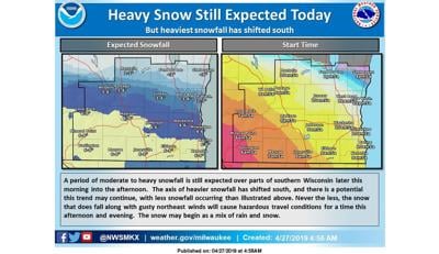
Southern Wisconsin on Saturday will get a potentially record-setting wintry blast more common in the middle of winter than late April, according to forecasters.
A winter storm warning took effect at 7 a.m. and runs until 10 p.m. Saturday, with 3 to 8 inches of snow and winds gusting to 35 miles per hour predicted.
The National Weather Service said snow will overspread the region from west to east, with snowfall rates of an inch per hour or more possible in the late morning and early afternoon, and the heaviest snow in the southern portion of southern Wisconsin.
“Significant travel impacts are likely, as several inches of wet, heavy slush accumulates on area roadways,” the Weather Service said.
Wisconsin travel conditions are available online or by calling 511.
In Madison on Saturday, 3 to 5 inches of snow is possible during the day and another inch at night, the Weather Service said.
Rain and snow is likely through 10 a.m., then snow after 10 a.m. that could be heavy at times and include some thunder.
The temperature is predicted to fall to around 33 by 4 p.m., with northeast winds of 5 to 10 mph increasing to 15 to 20 mph in the afternoon and gusting as high as 25 mph.
27 Storm Track meteorologist Guy Brown forecasts 1 o 2 inches of snow north of Dane County, 3 to 5 inches in the Madison area, and 5 to 8 inches to the south.
Posted by Dave the Lighthouse Keeper
DaveMcK
Honored Social Butterfly
- Mark as New
- Bookmark
- Subscribe
- Mute
- Subscribe to RSS Feed
- Permalink
- Report


DaveMcK
Honored Social Butterfly
- Mark as New
- Bookmark
- Subscribe
- Mute
- Subscribe to RSS Feed
- Permalink
- Report
02-25-2019
08:24 PM
To bad people don't listen to weather warnings!
Massive chain-reaction crashes are not new to Wisconsin. Here are some of the worst.

Posted by Dave the Lighthouse Keeper

DaveMcK
Honored Social Butterfly
- Mark as New
- Bookmark
- Subscribe
- Mute
- Subscribe to RSS Feed
- Permalink
- Report
02-08-2019
08:01 PM
Yesterday we had an ice storm and sleet along with a quick drop in temperature.
In the late evening we heard a thump on our roof and our first thought was that an ice coated branch landed on the roof. A little later there was another thump and aother. With everything ice coated we couldn't go outside
This morning I went outside and I couldn't see anything on the roof or ground. When I came inide Mary said that on the weather report they said we had ice thunder last night. Well I was surprised and happy to find out there was no damage.
Now ice thunder you say:
Thundersnow, also known as a winter thunderstorm or a thundersnowstorm, is an unusual kind of thunderstorm with snow or sleet falling as the primary precipitation instead of rain. It typically falls in regions of strong upward motion within the cold sector of an extratropical cyclone. Thermodynamically, it is not different from any other type of thunderstorm, but the top of the cumulonimbus cloud is usually quite low. In addition to snow, graupel or hail may fall.

Posted by Dave the Lighthouse Keeper
DaveMcK
Honored Social Butterfly
- Mark as New
- Bookmark
- Subscribe
- Mute
- Subscribe to RSS Feed
- Permalink
- Report
02-03-2019
11:06 AM
After about two weeks of bitter cold and snow storms here is a Winter view of one of my favorite places to visit in the Summer! Cana Island, Door County, Wisconsin February 2, 2019 - Photo by Jason Schroeder

Posted by Dave the Lighthouse Keeper


catwoman500
Trusted Social Butterfly
- Mark as New
- Bookmark
- Subscribe
- Mute
- Subscribe to RSS Feed
- Permalink
- Report
Turn on suggestions
Auto-suggest helps you quickly narrow down your search results by suggesting possible matches as you type.
Need to Know
.png)


Your Experts & Advisors